Field Trips by Ellin Beltz |
Fossil Localities - Humboldt Bay Area | ||
|---|---|---|
|
Always respect personal property rights and the environment when fossil hunting. For all ocean exposures, consult the tide tables and take all due precautions near the water. | ||
Bear River RidgeThe north flank of the Bear River Ridge south of Ferndale has northward tilted Wildcat layers and a ridge crest of Yager and Cape Mendocino-False Cape shear zone rocks (Oscar Larson and Associates, 1978). | ||
Rio DellNo specific locality is cited for Rio Dell. It is possible that these fossils came from the Scotia Bluffs just east of Rio Dell but were catalogued to the town name or, they were collected from the point bar at Rio Dell or an outcrop exists on the point bar side of the river which contains these fossils. | ||
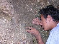
 Marco Mendez at Scotia Bluffs © 2004 Ellin Beltz
|
| |
Scotia BluffsIn addition to the mollusks and sand dollars commonly found, the Scotia Bluffs are reported to have produced some plants, turtles, starfish and agatized whale bone (Miller, 1999). Approach the bluffs from an access point on the southeast side of the Rio Dell/Scotia bridge. Walk along the railroad tracks (abandoned) under Highway 101 to the Bluffs. There is no automobile access beyond the parking lot that belongs to Pacific Lumber. Check in with their guard. If you're lucky, it's the gentleman who knows more about the local fossils than just about anyone else in Humboldt. Park your car with him or his coworkers.
| ||
BridgevilleNo specific location or species was given for the fossil whale bone found at Bridgeville, but a local collector says it was on private land well away from the river. | ||
Centerville BeachHookton/Carlotta, Scotia Bluffs and Rio Dell Formations coarsen upward and show filling of the basin over time (Stanley, 1995). Access Centerville Beach by driving 5 miles west from Ferndale along Centerville Beach road. Walk south along the beach only at low tide to the north dipping clay layer which contains the Giant Pacific Scallop fossils (Pectin caurinus). | ||
Blue LakeNo specific location was given for the mussels, Myliticus condoni, with "Blue Lake" as a locality. | ||
EurekaNo specific location was given for the sea urchin, Strongylocentrotus sp., with "Eureka" as a locality. | ||
Crannell JunctionEast of 101 on Crannell Road north of Arcata and South of Trinidad. Several papers mention fossils taken from a bluff in Crannell apparently connected with the now-abandoned railroad tracks. | ||
Pilot Point | ||
 Pilot Point Coquina © 2004 Ellin Beltz
|
Approximately 23 miles north of HSU near Moonstone Beach an exposure of fossil coquina on a steep and eroding cliff is productive of intact gastropods, other mollusks, sand dollars, huge barnacles, and the occasional mammal fossil including seal teeth. You can find fossils in the sand below the cliff and in the cliff face itself. There is little to no cement between the fossils; all but the gastropods require instant hardening or they do not survive removal. | |
Patrick's Point State Park | ||
You can observe living invertebrates in tide pools at Palmer's Point and Agate Beach or look for agates at the latter. Look against the light for the clear or nearly clear agates which are polished by the constant movement of the waves and sand. | ||
| Take another field trip... Chicago . Hawai'i . Humboldt County . Illinois . Wyoming | ||
|
Visit my Nifty Links...
Amphibians .
Archaeology .
Astronomy .
Australia .
Botany .
California .
Chemistry .
Chicago .
Dinosaurs .
Earthquakes .
Environmental Issues .
Ferndale .
Fossils .
Glaciers .
Humboldt County .
Illinois .
Kinetic Sculpture Races .
Lake Michigan .
Maps .
Math .
Minerals .
Moon .
National Parks .
Oceans .
Physics .
Plate Tectonics .
Rocks .
Rock Art .
Science Culture .
Volcanos .
Whole Earth | ||
|
Visit my home page ☯ Ellin Beltz - ebeltz@ebeltz.net
Updated: January 10, 2008 | ||